Thursday, July 21, 2005

Logging Blog


Logging Blog, originally uploaded by macatay.

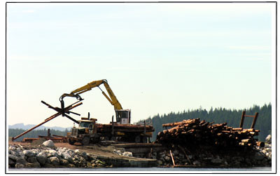
Port McNeil is a small city toward the north end of Vancouver Island, and our stop for groceries, water, fuel, and ice cream. It also remains an active logging port. Just across from the city dock there is a vast shoreside staging area where a vast number of log arrive in booms pulled by tugs. They are picked out of the water by a big crane, loaded onto trucks, and driven to a yard where they are scaled and sorted. Then they are loaded back onto the trucks, which return to the port at great speed, raising clouds of dust. The crane picks up an entire truckload of logs and returns them to the water, where they are again made up into booms and taken by other tugs to the mills. It is noisy, dirty, and it makes the giant logs look like tiny pencils.

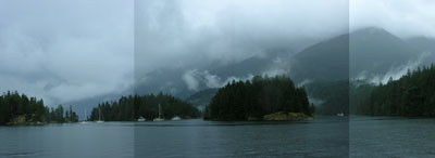
We’re headed the other way, north around Cape Caution where there are fewer boats, fewer log booms, and more whales, otters and sea lions. A marina is really just a trailer park, albeit a floating one. We give in to the irresistible urge to watch our neighbors and notice their boats and their docking maneuvers. We guess we are better off watching wildlife and clouds.

Pictographs for the Speechless


Pictographs for the Speechless, originally uploaded by macatay.

We have been rendered almost speechless by the discovery of unfamiliar territory, the interesting things we’ve learned from the people we’ve met, and the challenges of winds that vary daily from calm to gale.

We saw these pictographs on rocks at beautiful Echo Bay, and heard that they were 9000 years old. They spoke to our speechlessness.

Tuesday, July 19, 2005

Echo Cove


Echo Cove, originally uploaded by macatay.

It would be an exaggeration to call Echo Cove a natural harbour, not as we have come to understand harbours as places for ocean liners and tankers. But it is perfectly sized for fishing boats and runabouts and kayaks, and makes room for sailboats and the various motor vessels that cruise the BC Coast. Rocks ring the cove, some of them rising up several hundred feet in cliffs. Pictographs suggest it was home to very ancient peoples. It is now a hub for a network of people who have organized in opposition to current fishing farm practices.

I think the place feeds the passion. This is an enclosing, welcoming cove. Just outside the entrance, there are whitecaps and choppy waves. Inside there is relatively calm water. A few buildings perch on the rocky shores, but most are constructed on floats, and connected by wooden walkways. Just across the cove from our moorage, there is a spot where the walkway is a little wider, and an awning has been stretched to give some shade from the setting sun. Late in the afternoon, people gravitate to that spot and sit together into the evening. One more day here and we will overcome our shyness and join them.

Wednesday, July 13, 2005

Arbutus Land


Arbutus Land, originally uploaded by macatay.

April Point, British Columbia

Without really intending to, we have been lingering in arbutus land. Arbutus - also known as Madronne - grows only on the western coast of North America, and only as far north as the middle of Vancouver Island. They thrive on the rockiest shores, with their roots apparently squeezing into the cracks. The trunks of the older trees are elephantine in scale, and the limbs twist and stretch for the light. The bark, which is the color of cinnamon, peels back to reveal smooth wood that can be green, pale yellow, or red. They are the landscape's most perfect contrast to the acres and acres of dark conifers that line the shores.

Because Arbutus grow here along the shore of southern Vancouver Island, and because they favor open, exposed spots, we have come to associate them with warmth and sunshine. When we go north from here - as we plan to do tomorrow - we will be leaving the arbutus behind.

Monday, July 11, 2005

Anchoring in the Mountains


Anchoring in the Mountains, originally uploaded by macatay.

Tennedos Bay, Desolation Sound

Traveling in this part of coastal British Columbia, our anchorages are generally less than five miles from mountains of 8000 to 10,00 feet. It feels as if we are anchoring in the mountains, as each bay or cove is ringed by cliffs. It is difficult to comprehend the scale of things, especially when the tallest peaks are wreathed in cloud, and appear and disappear during the day. We can spend hours contemplating some immensely tall mountain nearby, only to discover, when the weather clears, that just behind it in the distance there are much taller snow capped peaks and ice fields. It is almost too much to absorb, so I settle for drawing the nearby cliffs and boats.

Sunday, July 10, 2005

Geography and Sentiment


Geography and Sentiment, originally uploaded by macatay.

Prideaux Haven, 7 July

Desolation Sound is the Ritz Plaza of Pacific Northwest crusing destinations. It’s drop dead scenic, with big peaks rising straight up on three sides, and a cluster of rocky inlets for anchorage. Plus, the water is warm here, even swimmable. On a clear day its lovely.

Obviously, Captain Vancouver’s crew saw it during a spell of bad weather, when the peaks were hidden in cloud, or appeared like giant rock walls, shutting off any possibility of the sought-after Northwest Passage. They named hundreds of places in these waters, and their emotional state seldom entered into the process. The exceptions are telling: there is Mistaken Island and Useless Inlet and the awesome Deception Pass. Misery Bay speaks for itself, as do Resolution Cove and Point Defiance. When feeling tentative, they named Beware Cove and Caution Cove. When less ambivalent, Grief Point and Fury Island. My all time favorite might have named for purely geographic reasons, but I can’t help but attribute an emotional twist to Point No Point.

Thick and Thin


Thick and Thin, originally uploaded by macatay.

The Sunshine Coast, British Columbia, 4 July

This mainland coastline is abruptly steep and very rocky. There are deep fiords cutting back into the coastal mountain range. The coves where there is anchorage are ringed by rock – big slabs, tilted blocks, domes bare of grass and trees.

All of these rocks are marked by fissures and cracks, which are especially apparent in the gray light of a rainy day. All of this three dimensional mass gets reduced to a network of dark lines, thick and thin. The kind of lines beloved of Chinese calligraphers or especially elegant caricaturists or cartoonists.

Friday, July 01, 2005

Canada Day


Canada Day, originally uploaded by macatay.

1 July, Nanaimo City Harbour

Festive waterfront crowds on Canada's big national holiday, with boats of all kinds, ferry crowds coming and going, families with kids, farmer's market. Harborside moorage means front row seats for all the action. The Canadians seem robustly flag proud.