Old Charts
The Bunsby Islands, Checlescet Bay, B.C.
N50°06.277
W127°30.892
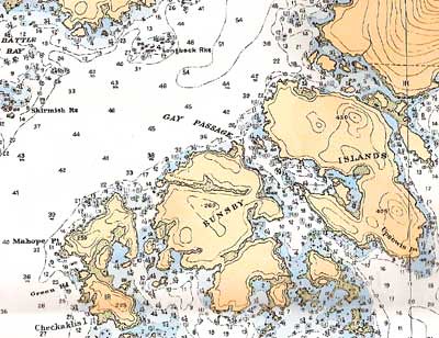
Among the navigation charts for British Columbia, there are a few that haven't been revised for decades. The one we are using now for Checlescet Bay, is based on a survey done between 1935 and 1937, and its typeface and appearance are entirely different than the newer charts. There is more detail and the place names are located more precisely. Topographic contours appear on all the land surfaces, and the names and heights of most peaks are included. Rocks and shoals are described with symbols that are quite varied, each symbol with its own meaning. It's a beautiful chart, a fine product of a map making tradition.
These waters deserve a detailed chart, because they are strewn with rocks and reefs and islets. This is a kayaker's paradise when the weather if fine, as it has been these last few days. We are anchored now in the Bunsby Islands and kayaked today in kelp, among rocks, in surf, and in still water. We portaged over a strip of beach piled with huge logs tossed up by winter storms, and watched seals chase herring out of the water. A big humpback whale welcomed us to the islands, and a sea otter came by at dinner time.
posted by s. v. Indigo at
10:57 PM
![]()


0 Comments:
Post a Comment
Subscribe to Post Comments [Atom]
<< Home