The Brooks Peninsula
Columbia Cove, Checlescet Bay, B.C.
N 50°08.29
W 127°41.52
The Brooks Peninsula sticks west out of the Vancouver Island shoreline like the nose on Pinocchio's face. The first European explorers called it the Cape of Winds. When we listen to the weather reports, there is always a special phrase, something like: "northwest winds, ten to twenty, except south of the Brooks Peninsula, where they will be twenty to thirty." That was the case today, when gale force winds were forecast.
But we've learned that the very high winds occur in the afternoon and evening, and that, on this trip down the west side of Vancouver Island, strong northwest winds are great for sailing. So we pulled up the anchor early, and sailed around the Brooks Peninsula before noon, with following winds of 15-20 knots and cloudy skies turning sunny as we reached the southern end of the peninsula. Indigo had the bit in her teeth, and we got in a few diesel-free miles.
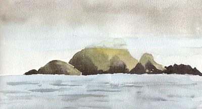
The illustration is of Solander Island, just off the northwesternmost tip of the Brooks Peninsula. Once you've rounded it, you have accomplished the worst part of the passage, so that Solander Island is a geographic icon. I love painting these iconic places; Francis Drake, Captain Cook, Bodega y Quadra, and Vancouver all gnashed their teeth as they rounded Solander Island, and so did we.
posted by s. v. Indigo at
7:53 PM
![]()


1 Comments:
Are you now headed back down south via a more adventuresome tack?
clw
Post a Comment
Subscribe to Post Comments [Atom]
<< Home