Georgia Strait Winds
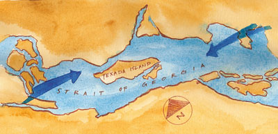
The Georgia Strait is an inland ocean, capped off by clusters of islands at either end and bordered by mountains that funnel the winds. With minor variation, the wind either blows down the Strait from the Northwest, or up the Strait from the Southeast. Summer winds are most often from the Northwest, so we were pleased to have the rare Southeast wind this morning when we left Nanaimo to head north. We had an exhilarating ride before the wind over a choppy, deep blue, white capped sea to our destination near Texada Island.
Texada Island is high, rising like a fin from the middle of the Strait. Winds intensify around its slopes. Our anchorage, on the protected side of Texada's smaller neighbor, Lasquiti Island, still has the traces of wind that come over land and sneak down to the lee shore. But we also have an "ocean" view, so the occasional gust seems like a small price to pay.
posted by s. v. Indigo at
2:36 AM
![]()


2 Comments:
I have noticed that you have done several painting of plan-view maps. Do you usually look at a map while painting?
You are in a great Salmon fishing area. This time of year there are both Kings and Silvers. And, the bottom fishing for snapper should also be great.
Send out the Captain.
clw
Post a Comment
Subscribe to Post Comments [Atom]
<< Home