Road Map Scale
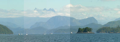
24 July, Wells Passage, BC: Always, there are the close-in shorelines, clothed in firs and cedars. Usually we can see to the surrounding hills rising up close to the shore. Occasionally, the clouds lift entirely and we can see back into the interior, past range after range of mountains, to the snow capped peaks and glaciers. Then we have to get out the road maps, because the nautical charts are too single in focus and small in scale to help us with this momentary glimpse of great distance.
posted by s. v. Indigo at
3:56 PM
![]()


1 Comments:
I love these panoramas, what software do you use to put them together?
Post a Comment
Subscribe to Post Comments [Atom]
<< Home