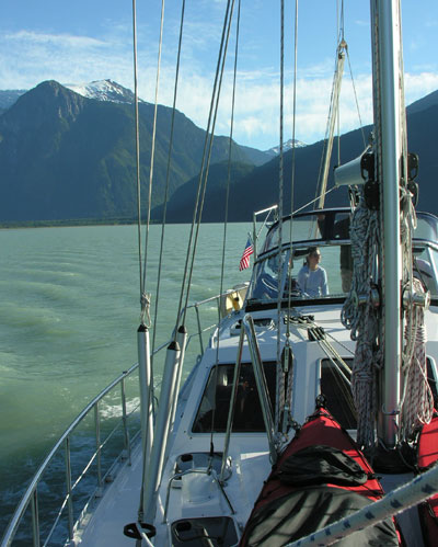
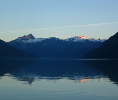
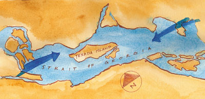
Monday, July 31, 2006

The Strait


The Strait, originally uploaded by macatay.

Chameleon Bay, Sonora Island, B.C.
N50°19.025
W125°24.587
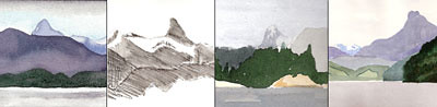
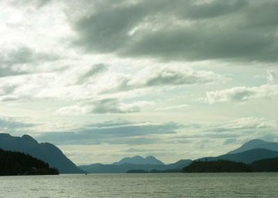
Now that we are through the Narrows, there is the Strait. The Johnstone Strait is a fifty-four mile passage bordered by tall mountains on either side. It is straight, and consequently is a famous wind tunnel where nasty, choppy seas build rapidly when the wind meets the tidal current. Quiet this evening, though, as the photo shows, and hopefully quiet tomorrow.
Strait is a good word, but I like straits even better. As in Dire Straits. I always said "the Johnstone Straits", or "the Straits of Georgia". I looked up 'strait' in The Sailor's Word Book, a fussy old book in our library written by an Admiral named Smyth in 1867. He says: "The word is often written in the plural, but without competent reason." Imagine that - ruled incompetent by an old sailor dead more than a century.

Sunday, July 30, 2006

The Narrows


We head north tomorrow into some wild geography, and first we must transit the Narrows. Seymour Narrows is one big, mean place in the passage between the Discovery Islands and the Vancouver Island shore. The waterway is constricted here to less than half a mile in width, causing the ebb and flow of the tide to reach alarming speeds – up to 14 knots of current. This is sobering now, but must have been terrifying when Ripple Rock sat in the middle of the narrows. Ships often were swept onto Ripple Rock until the 1958 when, as the photo above shows, it was blown sky high by 2.75 million pounds of dynamite. You can watch footage of the explosion at this Canadian Broadcasting website.

Saturday, July 29, 2006

Excellent Crew - Highly Recommended

April Point, near Campbell River, BC
N50°03.56
W125°14.49
We had to say goodby this morning to Sam and Kate, who are returning to life on shore and jobs and a house. We couldn’t have had better crew: they are compact, fit in the small space we provide for them, eat modestly, and are eternally cheerful and willing. We are happy to recommend them anytime.

Monday, July 24, 2006

Wind without Storm


Gorge Harbor, Cortes Island, BC
N50°05.99
W124°01.40
We have been experiencing an unusual phenomenon - gale force winds without an accompanying storm. Skies remain brilliant blue, and the temperatures are high. Winds in our anchorage last night gusted to more than 30 knots. This morning, we sailed south to Cortes Island with both the jib and main sail double reefed with winds of more than 40 knots. This evening, anchored in Gorge Harbor, the wind is finally dying down.

Sunday, July 23, 2006

Bute Inlet Water colors


Bute Inlet Water colors, originally uploaded by macatay.

Waiatt Bay, Octopus Islands Marine Park
N50°15.85
W125°13.60
This morning, on another incredibly clear day, we sailed back down the Bute Inlet with a following wind. Again, we were dazzled by the endless mountain ridges and peaks of granite and glacier, and by the good fortune to have wind to sail.
I spent most of the morning trying to capture the odd water color caused by glacial melt and mud in the outflow down the Inlet. In case you happen to track these things, the best and truest results came with mixes of cerulean blue and raw sienna.
Today is perhaps the hottest day we have ever experienced on the coast of British Columbia. Nearly everyone swam in the salt water to cool off. We suspect that our loved ones south of here and elsewhere may be even hotter.

Saturday, July 22, 2006

Beyond Superb Mountain


Waddington Harbor, at the head of the Bute Inlet
N50°52.54
W124°51.46
We woke up today to absolutely clear skies, so we pulled up the anchor and headed for the Bute Inlet. We traveled a total of sixty miles, but the last 35 were remarkable as the Inlet cuts right through the coast range. Now, at the head of the inlet, we are nearly surrounded by massifs and ranges capped with snowfields. The water in the inlet is a cloudy turquoise from all the glacier melt.
And, yes, we did find Superb Mountain, which is impressive, but is just one of the peaks in a chain of peaks, and that chain one of many that rise up 8,000 feet or more from the water.

Wednesday, July 19, 2006

The Captain's Dinner


The Captain's Dinner, originally uploaded by macatay.

The Captain is a fine cook. Tonight he made a beautiful stew of pork with butternut squash and carrots, served along with a brown rice pilaf. Extra effort is rewarded by the crew with accolades. We are four now, since Master Sam and his Kate have joined us. We are settled into Tennedos Bay, another of the remarkable Desolation Sound anchorages, this one ringed with high cliffs. Kate is smart, and has taken to swimming in the warm water each afternoon; the rest of us aren't so brave.

We are so pleased to have more crew with whom to share special things, like the Captain's Dinner.

Friday, July 14, 2006

Soaking the Anchor


Soaking the Anchor, originally uploaded by macatay.

Carrington Bay, Cortes Island, BC
N50°08.21
W125°00.15
That's what we are doing - we are soaking the anchor. We have set our anchor at the head of Carrington Bay, a deep inlet into Cortes Island, and are letting the wind and the current swing us around, theoretically digging our anchor deep into the gravel and rock at the bottom.
A side note: Chapman's, our basic nautical reference book, warns not to overdo the use of nautical terms: "It is hoped that the (boatman's) enthusiasm for boating will not cause him to toss indiscriminate 'AVASTS', 'AHOYS', and 'BELAYS' into every conceivable nook and corner of his conversation. Strained Efforts to affect a salty lingo are conspicuously inappropriate."
But it's just one term, and we like it: soaking the anchor. And we hope it holds, because there is a large, pristine lagoon beyond the bay here. Its outfall - quickly sketched above - is a short set of rapids. We hope to carry the kayaks over the land next to the rapids and kayak the lagoon. Once we've soaked the anchor.

Tuesday, July 11, 2006

In Search of Superb Mountain


In Search of Superb Mountain, originally uploaded by macatay.

The Octopus Islands, BC
N50°14.67
W125°10.83
We are heading toward Superb Mountain. Maybe we should explain. Among the impressive mountain ranges of both the British Columbia mainland and of Vancouver Island, there are a handful of distinctive peaks shaped like the Matterhorn, and sufficiently separate from their neighbors to draw attention. As we travel over the water, these unusual mountain tops come into view and then disappear behind some closer range or headland.
I've sketched them often while we were underway and from anchorages, and wanted to put a name to each peak. So we have gotten out maps, charts, compass, dividers, and plotter and tried to figure out which distant mountain was which. This is tricky, and we end up guessing. Compass direction (based on magnetic north) is different by about 21 degrees from map direction (based on true north), and land based maps don't ever fit quite right with water based charts. But Superb Mountain is one name found on both map and chart. And we discovered that we can travel by water forty miles up the Bute Inlet right to the base of Superb Mountain, so we figure we have some chance of getting a good look at it.
So now we are hanging out in the rain in the Octopus Islands, poised for a trip up Bute Inlet, which we will make the first day the skies clear. Life seems richer when you are on a quest.

Sunday, July 09, 2006

Never, Never Land


Never, Never Land, originally uploaded by macatay.

Desolation Sound is famous for its spectacular mountain vistas, but also for its warm water which is great for swimming - the water here today is 73 degrees. We are anchored in Laura Cove which has room for a half dozen boats. This weekend, by coincidence, all the other boats here have kids aboard - lots of them - and most of them are boys. About a dozen boys between the ages of seven and seventeen.
Laura Cove also has a rope swing hung from a big old fir tree that leans out from the steep shore. All day on this warm sunny Sunday, there have been boys swinging out on that rope and leaping into the water, boys riding around in dinghies, boys dangling from boats, boys climbing on rocks and pushing each other into the water. It reminds us of Peter Pan, of Never, Never Land. There is one girl, about twelve, and she leaps further and climbs faster than the boys, so we figure she is a modern day Wendy.

Saturday, July 08, 2006

Juxtapositions


Juxtapositions, originally uploaded by macatay.

An odd near/far juxtaposition from travels yesterday as we entered Desolation Sound. The peaks of the Unwin Range make an interesting contrast to the books in our reference library.
We've enjoyed the onboard comforts for the last few days, since the fine weather has finally ended, and we've had clouds and rain. After a long kayak paddle in the drizzle today, capped by a swim in the warm water, we dried out with a sauna. Another fine juxtaposition.

Thursday, July 06, 2006

Georgia Strait Winds


Georgia Strait Winds, originally uploaded by macatay.

The Georgia Strait is an inland ocean, capped off by clusters of islands at either end and bordered by mountains that funnel the winds. With minor variation, the wind either blows down the Strait from the Northwest, or up the Strait from the Southeast. Summer winds are most often from the Northwest, so we were pleased to have the rare Southeast wind this morning when we left Nanaimo to head north. We had an exhilarating ride before the wind over a choppy, deep blue, white capped sea to our destination near Texada Island.
Texada Island is high, rising like a fin from the middle of the Strait. Winds intensify around its slopes. Our anchorage, on the protected side of Texada's smaller neighbor, Lasquiti Island, still has the traces of wind that come over land and sneak down to the lee shore. But we also have an "ocean" view, so the occasional gust seems like a small price to pay.

Sunday, July 02, 2006

Canada Day

We crossed back into Canada yesterday. Coincidentally, it was Canada Day, a holiday with lots of the same festivities as our Fourth of July, and marked by a long weekend locally. Add to this the spectacular weather - this is the eleventh straight day of brilliant sunshine and warm temperatures - and you have conditions that have drawn every boat from every harbor from Seattle to Vancouver Island. It's downright festive, and totally unlike what we are accustomed to in the Pacific Northwest. Lots of Canadian mapleleaf flags flying from halyards.